Allie's Valley
The flight across the rugged Chugach mountains take you to this beautiful remote valley. Surrounded by hanging glaciers at the end of a long alpine valley, you will feel like the only persons on Earth. From here you can explore your valley, or cross a pass and check out the headwaters of another valley. The options are virtually endless.
USGS maps: Bering Glacier D6
Super cub strip.
Doubtful Creek
Located near the lake at the Nizina Glacier terminus, this location offers a variety of hiking terrain and expansive views dominated by nearby Nizina and Chimney Mountains. Follow the river bank upstream, along the glacier margin where blue ice is exposed by calving, seek out waterfall fed rock pools off of Moonshine Creek or ascend Doubtful Creek into the higher country.
USGS maps: McCarthy C4
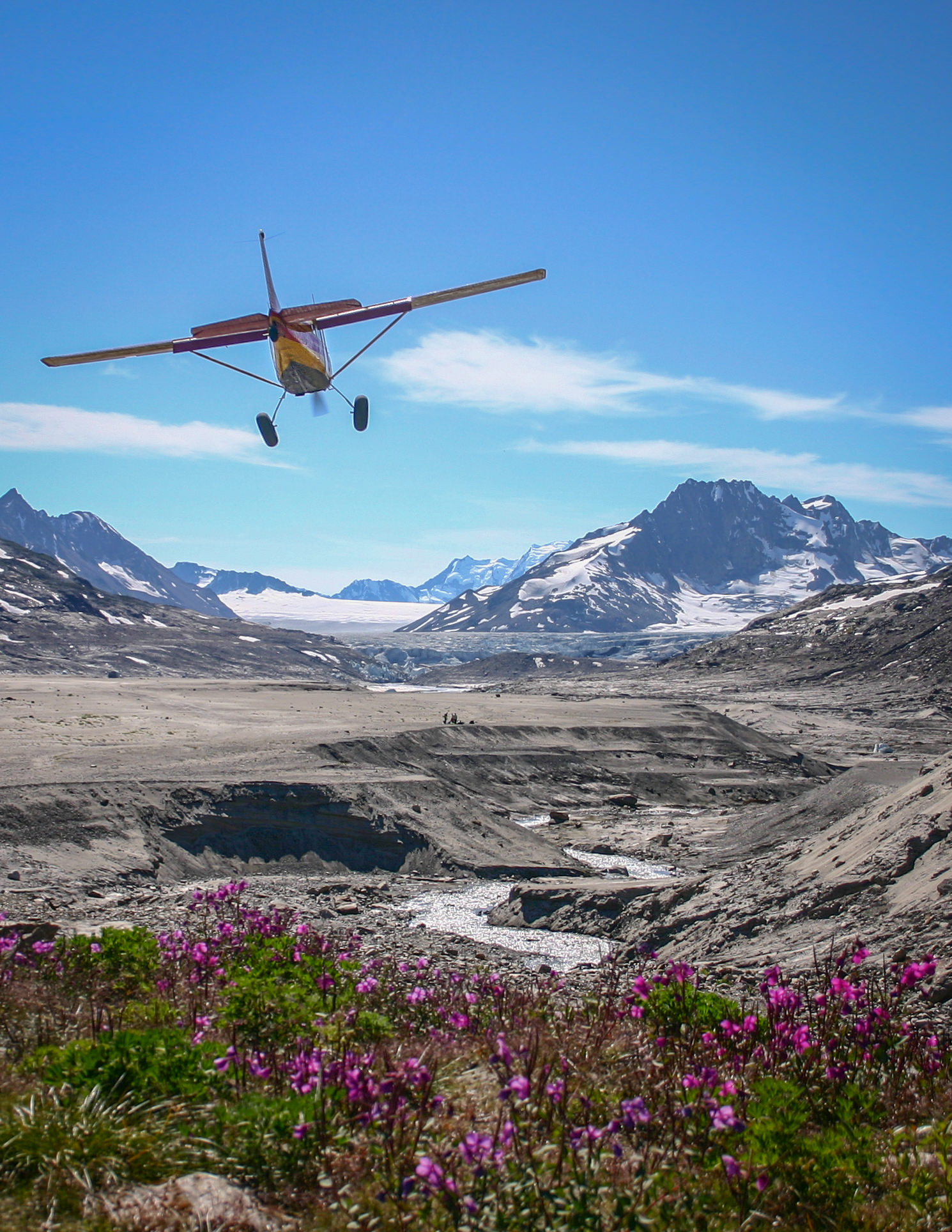
Fan Glacier
Located to the south of McCarthy about 50 miles, the Fan Glacier area offers great base camping and day hiking. Surrounded by high peaks, with glaciers in every direction the views are stunning. Although there is some low brush on the lower slopes the ridge to the north is accessible from the landing area. Hiking above the lower brush band is in alpine tundra and amongst small ponds that stud the ridge like aqua blue jewels. From here you will be able to see 100 miles on a clear day. Just off of the airstrip are some beautiful small lakes which make a wonderful camping spot. There are long and beautiful sand bars to stroll if a hike up the mountain is not your thing.
USGS maps: Bering Glacier D1, D7, and D8.
The Fosse
Tucked neatly between the Kennicott Glacier’s lateral moraine and the base of the adjacent mountain, this landing strip offers a variety of amazing glacier views and exploring options. Hike along the flat fosse terrain, climb the green alpine slopes above or walk along the Kennicott Glacier.
USGS maps: C6
Horsfeld
The flight out of McCarthy will take you through beautiful Skolai Pass and down the White River before heading west into the Nutzotin Mountains. You get to see a lot of the park on this flight. There are opportunities for day trips in all directions out of Horsfeld or you could do a loop trip. Lakes and valleys to the north invite exploration or make the crossing of Beaver Creek and explore the hills and mountains to the south. The variety of terrain ensures that there is something interesting and challenging for hikers of all abilities. This part of the park is seldom visited.
USGS maps: McCarthy D1, D2 and Nabesna A1, A2
Iceberg Lake
Near wide views of massive Bagley Icefield, this landing strip offers a variety of hiking terrain. Enjoy easy hiking along the lake; access the nearby white ice of Tana Glacier or climb steep slopes to higher elevations. Glaciers spilling from hanging valleys, the roaring creek and calving ice all accompany the stunning solitude.
USGS maps: Bering Glacier C6, D6
Nikolai Pass
In the alpine country of Nikolai Pass, look to Mt. Blackburn (16,390’) in one direction, the snowy University Range (16,421’) in the other, and the glacial waters of Nizina River 2400’ below. Hike along rolling slopes toward the base of Sourdough peak, or explore nearby remains of old Nikolai Mine. Great photo opportunities.
USGS maps: McCarthy B5
Super cub strip.
Nizina Glacier
Land at the end of glacier lake filled with icebergs from nearby Nizina Glacier. The views from the lakeshore are outstanding and there is a public use cabin tucked into the wood about a half a mile from the airstrip. This area offers casual hikes along the lakeshore and gravel bars along the Nizina River as well as routes up Nizina Mountain to alpine areas above treeline. This spot has it all; glaciers, rivers, mountains and a snug cabin in a pretty setting.
USGS maps: McCarthy C4, C5
Ross Green Lake / Granite Creek
Located at the base of jagged Thompson Ridge, innumerable surrounding peaks compose an exciting alpine landscape. From the landing area on a sand bar near Ross Green Lake, explore along Granite Creek or climb to higher elevations. See long open views of Tana Glacer to the west, stretching from the giant Bagley Icefield, which lies just 5 air miles away to the south.
USGS maps: Bering Glacier C5, D4, and D5
Skolai Pass
From the landing strip at 4500’, behold Russell Glacier spilling rocky ice into the gravely expanse of the White River bar. Exploring the alpine terrain, views of Hole in the Wall Glacier, icy University Range (16,421’) and grazing caribou call you in all directions.
USGS maps: McCarthy C3
Steamboat Hills
This is a delightful area for base camping, especially for families. You will be surrounded by a magical, almost pastoral landscape of rolling hills sprinkled with tiny lakes that sparkle like freshly cut emeralds nestled among velvety green pillows. At the periphery of the central hill country is a ragged ridge line of rugged crags and peaks that form a dramatic backdrop to the gentler terrain of our route. One of the highlights of this area is the opportunity for viewing the many Dall sheep that inhabit the area. The wide open terrain makes them easy to spot from afar. But bring your telephoto lens if you want to get up close and personal with these elusive animals.
No minimum passengers. Super cub strip.
USGS maps: McCarthy A7, A8, B7, B8
Tebay Lakes
Land in open meadows at the end of a lake-filled valley. Encompassed by hanging glaciers and jagged mountains, enjoy rainbow trout fishing in the blue alpine waters. You can day hike two miles to a large waterfall or pick your way up the rocky, green slopes to higher elevations.
USGS maps: Valdez A1, A2
Wolverine Mountain
Located on an alpine bench above Chitistone Canyon, this 5000’ home for Dall sheep and mountain goats, is an excellent spot for day hiking and backpacking. View the snowy ampitheater of the University Range from nearby higher terrain.
USGS maps: McCarthy C4
Wrangell Plateau
Take a hike along the lower slopes of Mt. Wrangell. The broad, trundle plateau gives you unobstructed views and easy access to the icy Western side of this 13,887’ peak. On a clear, windless day you may catch a glimpse of the steam plume rising lazily from this active volcano. Hiking is easy to moderate on alpine tundra, and good camping spots can be had near small lakes and numerous clear streams. For the alert backcountry traveler, this location offers good opportunities to see caribou, dall sheep, wolves and bears.
USGS maps: Valdez D1